American country singer Willie Nelson reckons it was disgusting how everyone treated Lance Armstrong, especially after what he achieved, winning seven Tour de France titles whilst on drugs. When Willie was on drugs, he says, he couldn’t even find his bike. At least he can take comfort from the fact that Mr.Armstrong is still able to compete against other cyclists with Strava, an app which tracks cyclists activity via GPS and allows riders to compare their own performance against others.
There are users of the popular app that take exception to the fact that input from Lance Armstrong’s road trips are swashing around the companies vast data pools which has prompted calls for the disgraced cyclist to be banned from using Strava. In the interests of not wanting to become a ‘police state’ Strava Chief Exec, Michael Horvath, says it will not happen. Strava look at far more stimulating ways of calling data than to block L.A.
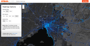
Introducing Strava Labs which has created a small buffet of projects separate to the San Francisco firm’s main product which aim to maximise the companies’ use of data for users on 250 billion GPS data points. Global Heatmap, shown above, layers Strava data over Google Map data to create a detailed global impression of journeys taken by Strava users. The composition shows the most used routes globally as a more vivid score on the map with different Heatmap styles and opacity, switchable between run and cycle.
The Routing Errors feature allows users to report positions where there are inconsistencies with maps or if Strava’s route builder will not allow the user to use a trail which is shown on the map. This feature uses OSM which allows editing under open license and allows users to add their own trails.
Slide is a server side tool written in Go which leverages the Strava GPS global dataset and allows users to input a very crude route which the app will improve and output a ‘slided’ polyline which represents the true path of travel. Slide works by allowing the route line, described as a string of beads, to effectively fall into the valley of previously defined routes on a map using a three part cost function of depth, distance between resampled points and vertex angles. This is done by generating a surface which takes the GPS data points and builds a density distribution of where the points should be with the denser points being deeper valleys. Slide is perceived as a way of correcting routes and Strava do not envisage it as an automated tool that is going to run over the entire OSM dataset but more a tool for experienced OSM editors to optimise their time using datasets available and in future could be used to ‘slide’ more complex geometries.
Currently the source for Slide ID Editor integration is available at Github.


